via Florida Tech Today
It’s the ultimate techno-toy. And Patrick Lewis gets to play with it.
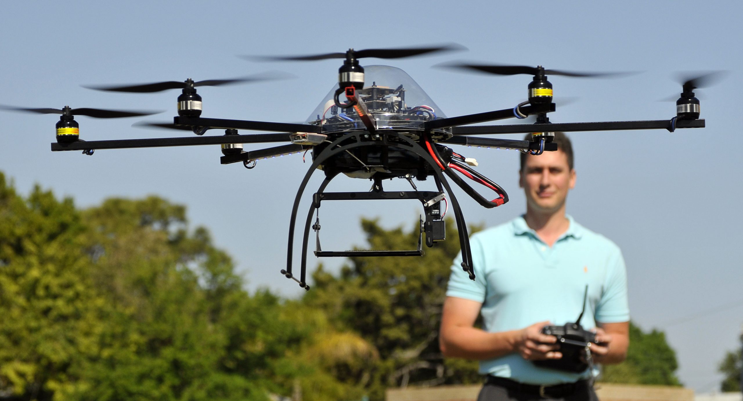
Working on his master’s degree in systems engineering, Lewis is a member of the university’s Information Characterization and Exploitation (ICE) Laboratory. He’s the systems integrator on the eight-rotor, 2 kilogram (4.4 pound) OktoKopter, the tool for his thesis project. For his thesis he will geo-reference the imaging data collected from the OktoKopter’s camera payload.
Lewis says, “I got really lucky. This project was a gift that just dropped into our laps and my interests were a great match.”
With the support of faculty adviser and engineering systems professor Adrian Peter, Lewis was going to conduct his thesis project as a simulation. However, a small Melbourne defense contractor, RadiantBlue Technologies, funded the work by purchasing the $6,200 battery-powered, German-made OctoKopter for mutual benefit.
“Radiant Blue asked us to do a feasibility study and collect some video from the UAV,” said Peter, the ICE Lab’s co-director.
Lewis is in charge of the project. He made the copter flight-ready, oversaw the camera integration and wrote its geo-referencing algorithms. Out in the open air with remote control in hand, he’s also the test pilot.
The fact that he learned some German in high school has helped him over the challenges of the drone’s software being written partly in German.
He’s programming the OktoKopter’s smartphone camera to transmit video to a laptop running software that calculates the GPS coordinates of objects or people on the ground.
His work involves merging the video signal with a computer program so the coordinates may be viewed. For this, he says, “You need to make a bunch of mathematical transformations related to aerial photography concepts.”
Lewis, who holds a private pilot’s license, says that flying the device is, in a way, more difficult than flying a full-size aircraft. “It requires more sensitivity of touch.”
The microcopter can carry up to two pounds, fly as long as 15 minutes on a single battery charge and reach an altitude thousands of feet above the ground. Federal Aviation Administration regulations, however, limit it to 400 feet. “You can barely see it up in the sky,” says Lewis.
For Radiant Blue, the data from the feasibility analysis for streaming video applications will ultimately result in a demonstration of the company’s capabilities and potentially attract new customers.
Not just for the military, anymore, unmanned multi-rotor helicopters such as the OktoKopter, can with mounted cameras, be used for mapping operations, as in this work, and for many other applications. These include traffic monitoring, sports and TV news aerial photography, law enforcement assists, search and rescue, firefighting, building inspection and crop health analysis. They save costs and can go where it may be unsafe to send a human.
For Lewis, the result will be his thesis: geo-referencing the aerial video and registering it to a map of the Earth. Geo-referencing refers to defining the existence of something in physical space. That is, establishing its location in terms of map projections or coordinate systems.
He’s on his way to a successful thesis, according to Peter, who said, “Patrick exemplified hard work and dedication throughout the research project. He is very self-motivated, researching issues on his own and finding the best way forward when problems occur. He was in the lab daily working on the copter and ensuring that we were always making progress. As an adviser, these are the qualities that we like to see in students, and they will undoubtedly make him successful in his professional career.”
With assistance from Ken Wallenstein, adjunct professor, Lewis hopes to simplify the approach to geo-referencing aerial video. “At the very least, I hope to make the process much more understandable and establish a good knowledge base for continuing research,” he says.
With his new micro-UAV technology expertise, the project should open up many opportunities for Lewis after he graduates. His experience as a Boeing flight test engineer in an internship in Seattle last summer won’t hurt, either. He’s undecided right now if he will go right into industry or continue his education and pursue a doctoral degree.
“I’ve always been interested in aviation and robotics. This brings it all together for me,” says Lewis. “It’s a tremendous learning experience with, I hope, some quite valuable outcomes.”